


Spain Topo Maps

Opis aplikacije Spain Topo Maps
+++ Нови ГПС Мапирање Апп +++
Лака за кориштење вањска / Оффлине ГПС навигацијска апликација с приступом најбољим топографским картама и зрачним сликама за Шпањолску.
Укључујући Балеарска острва и Канарска острва
++ За оффлине употребу потребно је ПРО могућности! ++
Претворите свој Андоид телефон / таблет у отворени ГПС за путовања у бацкцоунтри БЕЗ ПОКРИВЕЊА ЦЕЛИЦА. Ова апликација вам даје сличне опције мапирања као што можда знате из ГПС ручних уређаја.
Укључени бесплатни слојеви карте:
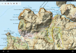
• Спаин Топо Мапа: Мапа Топографицо Национал 1: 50.000 & 1: 25.000 (ИГН МТН25 & МТН50)
• ИГН Басе Мап: Национална база Топографица 1: 25.000 (БТН25 & БЦН25)
• Слике у Шпанији: Слике из ваздуха високе резолуције. План Национал де Ортофотографиа Аереа (ПНОА)
• Цаталониа Топо Мапс: Топографске карте високе резолуције за Каталонију
• Земљописна мапа: Цартографиа Цатастрал
• ОпенСтреетМапс: Ове мапиране публикације су веома користан додатак другим слојевима карте. Садржи многе јединствене карактеристике.
• ОпенЦицлеМапс: Ове мапе су идеалне за планирање бициклистичких путовања
• ЕСРИ Топографија
• ЕСРИ Аериал Имагес
• ЕСРИ Стреет Мап
• Гоогле путна карта (само мрежни приступ)
• Гоогле сателитске слике (само онлине приступ)
• Гоогле Терраин Мап (само онлине приступ)
• Бинг путна карта (само онлине приступ)
• Бинг сателитске слике (само онлине приступ)
• Земља ноћу
• Прекривна маса за брисање
Главне карактеристике за навигацију на отвореном:
• Креирање и уређивање путних тачака
• ГоТо-Ваипоинт-Навигатион
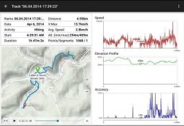
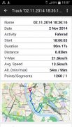
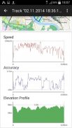
• Снимање нумере (са профилом брзине, елевације и тачности)
• Трипмастер са пољима за одометар, просечну брзину, лежај, висину итд.
• Извоз ГПКС / КМЛ / КМЗ
• Претрага (имена места, ПОИ, улице)
• Прилагодљива поља података у приказу мапе и Трипмастер-у (нпр. Брзина, удаљеност, компас, ...)
• Делите путне тачке, стазе или руте (путем е-поште, Вхатсапп, Дропбок, Фацебоок, ..)
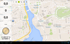
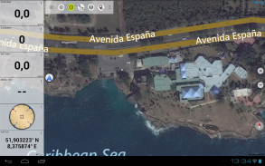
• Прикажи координате у Лат / Лон, УТМ или МГРС / УСНГ (Војна мрежа / Национална мрежа САД-а)
• Снимање и дељење нумера са статистиком и профилом елевације
• Ротирај мапу (Трацк Уп & Нортх Уп)
• Гет Елеватион дугим кликом на мапу
• Трацк Реплаи
• и још много тога ...
Доступне карактеристике Про: (Про функције доступне путем Ин Апп Пурцхасе)
• Оффлине Усе - није потребна покривеност ћелије
• Еаси + Фаст Булк-довнлоад мапа плочица за ОФФЛИНЕ УСАГЕ (не за Гоогле и Бинг мапе)
• Креирање и уређивање рута
• Навигација руте (навигација од тачке до тачке)
• Увоз ГПКС / КМЛ / КМЗ
• неограничене путне тачке и трагови
• Додај други послужитељ мапа мапа
• Нема огласа
Изванмрежна употреба:
Све прегледане плочице мапа чувају се у кешу. Да бисте кеширали велике површине, морате купити Про функције.
Користите ову навигацијску апликацију за активности на отвореном као што су планинарење, бициклизам, камповање, пењање, јахање, скијање, кану, лов, оффроад 4ВД туре или претраживање и спашавање (САР).
Додајте прилагођене тачке у формату дужине / ширине, УТМ или МГРС / УСНГ са датумом ВГС84.
Увоз / извоз / дељење ГПС-путних тачака / стаза / рута у формату КМЛ / КМЗ програма Гоогле Еартх или Гоогле Еартх.
Унапред учитајте БЕСПЛАТНЕ податке о мапама за области без услуге ћелија (Про функција!).
Коментари и захтјеви за особине на спаинмапс@атлогис.цом
Погледајте наше друге апликације за навигацију на отвореном: хттпс://плаи.гоогле.цом/сторе/сеарцх?к=атлогис
+++ НЕ пратимо активности корисника или прикупљамо било какве корисничке податке! +++
Spain Topo Maps - Verzija 7.7.0
(20-02-2025)
Spain Topo Maps - Informacije o APK datoteci
Verzija APK datoteke: 7.7.0Paket: com.atlogis.spainPoslednja verzija aplikacije Spain Topo Maps
Druge verzije


Aplikacije u istoj kategoriji

Možda će vam se takođe dopasti i...


